> For the complete documentation index, see [llms.txt](https://support.senterasensors.com/fieldagent-documentation-updates/llms.txt). Markdown versions of documentation pages are available by appending `.md` to page URLs; this page is available as [Markdown](https://support.senterasensors.com/fieldagent-documentation-updates/export-and-share/download-and-export-data.md).
# Download and export data
Every way to get data out of FieldAgent Web: layer downloads (GeoTIFF, GeoJSON, CSV, Shapefile), zone boundaries, prescriptions, original photos, PDF reports, and table exports.
FieldAgent Web stores your data in the cloud, and everything it shows can be taken out again for use in GIS, farm management software, or a report. This page lists where each kind of download lives.
The demo below is a working, view-only copy of FieldAgent Web with the steps for downloading zones and layer files. Follow them in the copy, or press **Show me** to watch each one.
{% @fieldagent-demo/embed content="download-data" %}
Open this demo full size
## Layer data
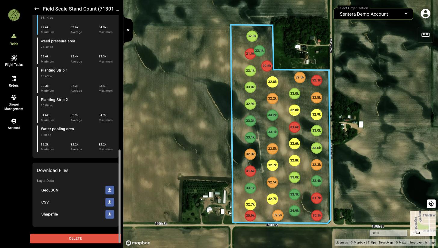
1. Turn on the layer and click its name in the **Map Layers** card to open its details.
2. Scroll to **Download Files** at the bottom of the panel.
3. Click the download icon next to each file you need.
Download Files at the bottom of a layer's details.
| Layer | Files |
| ----------------------------------------------------------- | ------------------------------------------------------------------------------------------------------------------------------------------------------------------------------------------- |
| Stand Count, Tassel Count, and other sample-based analytics | **GeoJSON**, **CSV**, and **Shapefile** of the samples with their values |
| Mosaics and QuickTiles | GeoTIFF of the layer |
| Zone Rx prescription | The prescription file from **DOWNLOAD RX** in the **Zone Rx (Beta)** display mode; see [Zone Rx prescriptions](/fieldagent-documentation-updates/export-and-share/zone-rx-prescriptions.md) |
{% hint style="info" %}
A shapefile is a set of several files that must be kept together. Download every file offered for the shapefile, and keep them in the same folder.
{% endhint %}
## Field boundary and zones
The menu (three dots) on the **Zones** card in the field view downloads the field boundary and the zones you have drawn as **GeoJSON**, **Shapefile**, **CSV**, or **KML**. See [Zones and zone statistics](/fieldagent-documentation-updates/view-and-analyze/zones-and-zone-statistics.md).
## Original photos
Open a photo from the **Photo Dots** layer, or a sample from a stand or tassel count, and click the download icon at the top of the image viewer to save the original photo file. See [Photo dots and the image viewer](/fieldagent-documentation-updates/view-and-analyze/photo-dots-and-image-viewer.md).
## PDF reports
**CREATE REPORT** in the field view builds a PDF of the field with the layers you have on. See [Create a report](/fieldagent-documentation-updates/export-and-share/create-a-report.md).
## Tables
The **Orders** and **Flight Tasks** pages have an **EXPORT** button in the table toolbar that downloads the table with the current filters applied. See [Orders and flight tasks](/fieldagent-documentation-updates/ordering/orders-and-flight-tasks.md).
## Sending data to other platforms
* A Zone Rx prescription can be sent straight to John Deere Operations Center with **SEND TO OPERATIONS CENTER**.
* When the John Deere Operations Center connection is active, the **Send Map Layers to Field Analyzer** switch in **Account** › **Connections** pushes map layers to Operations Center. See [Account settings](/fieldagent-documentation-updates/account-and-organizations/account-settings.md).
* Field boundaries and mosaics can also be exported to John Deere Operations Center from FieldAgent Desktop; see [Send data to Operations Center](/fieldagent-documentation-updates/integrations/send-to-operations-center.md).
## Related pages
* [Map layers](/fieldagent-documentation-updates/view-and-analyze/map-layers.md)
* [Zone Rx prescriptions](/fieldagent-documentation-updates/export-and-share/zone-rx-prescriptions.md)
* [Create a report](/fieldagent-documentation-updates/export-and-share/create-a-report.md)