> For the complete documentation index, see [llms.txt](https://support.senterasensors.com/fieldagent-documentation-updates/llms.txt). Markdown versions of documentation pages are available by appending `.md` to page URLs; this page is available as [Markdown](https://support.senterasensors.com/fieldagent-documentation-updates/fields/create-a-field.md).
# Create a field
Create a field in FieldAgent Web by drawing its boundary on the map, or import fields from John Deere Operations Center or Climate FieldView.
A field is the container for everything FieldAgent stores about a piece of ground: its boundary, the imagery flown over it, the mosaics and analytics ordered from that imagery, zones, and reports. Create a field before you fly it so the flight plan in FieldAgent Mobile and the imagery you import land in the right place.
There are two ways to create fields in FieldAgent Web: draw the boundary yourself, or import fields from a connected partner. Field boundaries can also be imported from shapefiles in FieldAgent Desktop; see [Mass Import of Field Boundaries](/fieldagent-documentation-updates/fieldagent-desktop/fieldagent-desktop/mass-import-of-field-boundaries.md).
The demo below is a working, view-only copy of FieldAgent Web. It walks through the Create New Field form — name, details, state, the drawing tools and SAVE. Follow the steps in the copy, or press **Show me** to watch each one.
{% @fieldagent-demo/embed content="create-field" %}
Open this demo full size
## Draw a field
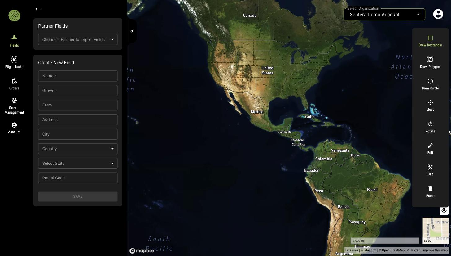
1. Open **Fields** and click the plus icon at the top of the **Fields** panel. The **Create New Field** form opens and the drawing tools appear on the right edge of the map.
2. Zoom and pan the map to the field. Switching the basemap to satellite imagery (thumbnail in the bottom-right corner) makes the field edges easier to follow.
3. Enter a **Name**. The other fields (**Grower**, **Farm**, **Address**, **City**, **Country**, **Select State**, **Postal Code**) are optional. Grower and Farm appear in the field list and can be searched and sorted.
4. Draw the boundary with one of the drawing tools (see below). A field can contain more than one boundary shape.
5. Click **SAVE**.
The new field opens in the field view and is available immediately in FieldAgent Mobile and, after the next sync, in FieldAgent Desktop.
The Create New Field form and the drawing tools.
### Drawing tools
| Tool | How to use it |
| ------------------ | ------------------------------------------------------------------------------------------------------------------------------------------------- |
| **Draw Rectangle** | Click to place one corner, move the cursor, and click to place the opposite corner. |
| **Draw Polygon** | Click to place each corner of the shape. Click the first or last point to close the polygon. |
| **Draw Circle** | Click to place the center, move the cursor to set the radius, and click to confirm. |
| **Move** | Click a shape to select it, then drag it to a new position. |
| **Rotate** | Click a shape to select it, then drag the handle above the shape to rotate it. |
| **Edit** | Click a shape to select it. Drag a point to move it, or click on an edge to add a point. |
| **Cut** | Draw a polygon over an existing shape; the area you draw is removed from the boundary. Use it for waterways, buildings, and other excluded areas. |
| **Erase** | Click a shape to delete it from the field. |
## Import fields from a partner
If your account is connected to John Deere Operations Center or Climate FieldView, the **Partner Fields** card at the top of the **Create New Field** page lists the connected partners under **Choose a Partner to Import Fields**. Select the partner and choose the fields to import. The list is empty when no partner is connected; connect one from **Account** › **Connections**. See [Account settings](/fieldagent-documentation-updates/account-and-organizations/account-settings.md).
Imported fields keep the name, boundary, and farm from the partner. When fields are re-imported from Climate FieldView, those details are updated to match Climate FieldView; the field is not duplicated and its map layers stay in place. For the import steps, see [Import fields from Operations Center](/fieldagent-documentation-updates/integrations/import-fields-from-operations-center.md) and [Connect with Climate FieldView](/fieldagent-documentation-updates/integrations/connect-with-climate-fieldview.md).
## Related pages
* [Edit or delete a field](/fieldagent-documentation-updates/fields/edit-or-delete-a-field.md)
* [Find a field](/fieldagent-documentation-updates/fields/find-a-field.md)
* [Crop seasons and field activities](/fieldagent-documentation-updates/fields/crop-seasons-and-field-activities.md)