> For the complete documentation index, see [llms.txt](https://support.senterasensors.com/fieldagent-documentation-updates/llms.txt). Markdown versions of documentation pages are available by appending `.md` to page URLs; this page is available as [Markdown](https://support.senterasensors.com/fieldagent-documentation-updates/get-started/tour-of-fieldagent-web.md).

# Tour of FieldAgent Web

The parts of the FieldAgent Web interface: the navigation rail, the organization selector, the Fields panel, the map, and the field view.

FieldAgent Web has a fixed layout: a navigation rail on the left, a panel next to it, and the map filling the rest of the window. The organization selector and the account icon stay in the top-right corner on every page.

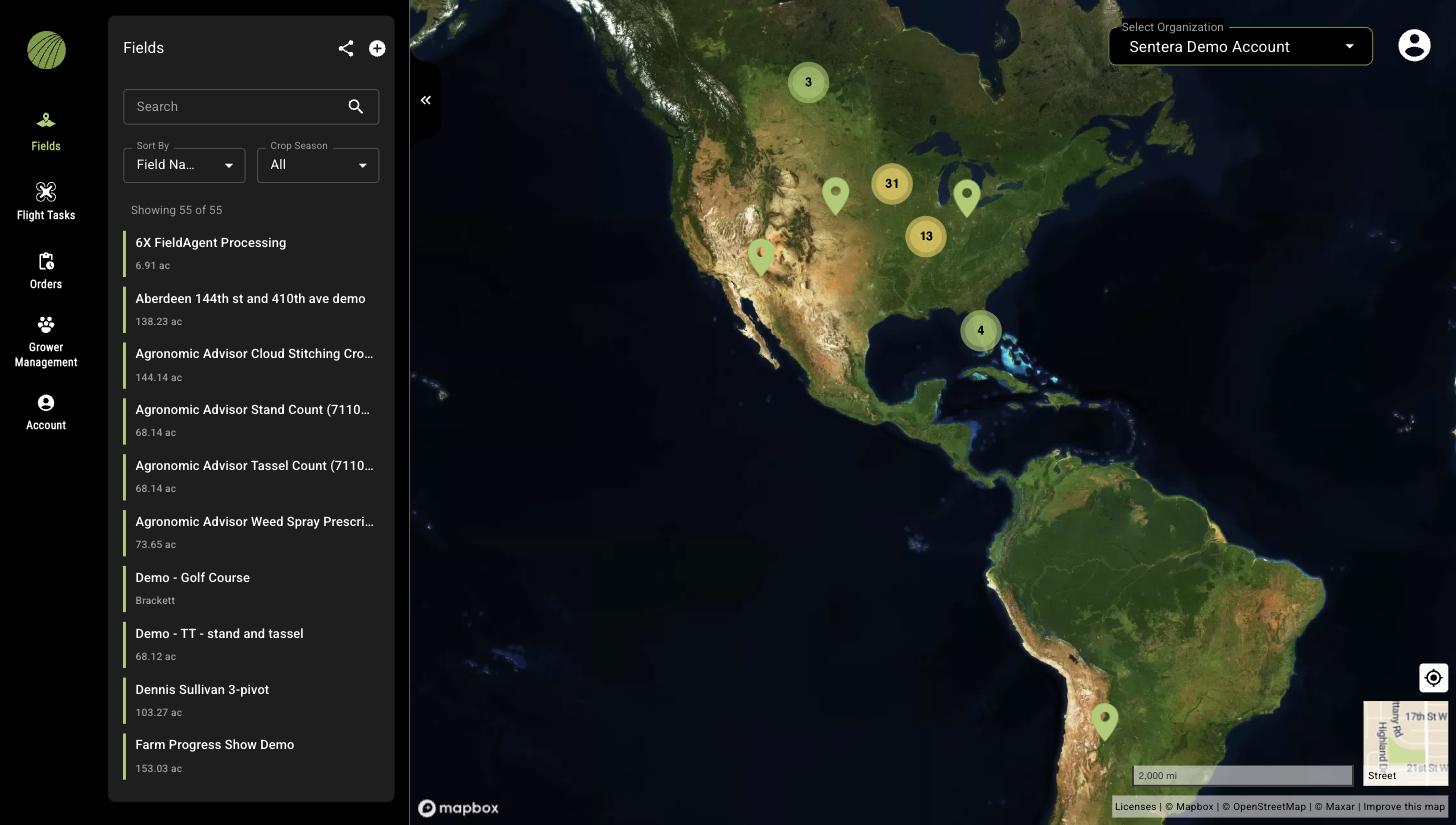
<figure><img src="https://4042936416-files.gitbook.io/~/files/v0/b/gitbook-x-prod.appspot.com/o/spaces%2FNnNa4XKy1hMfEEmHLPqZ%2Fuploads%2Fgit-blob-dd1ad6b8d3b6fb91ba120b497095590f6d5a1081%2Ffa-web-fields-page.jpg?alt=media" alt="FieldAgent Web with the Fields panel open and a map of North America showing clustered field markers"><figcaption><p>The Fields page. The panel lists the fields in the selected organization; the map clusters them by location.</p></figcaption></figure>

The demo below is a working, view-only copy of FieldAgent Web. Pan and zoom the map, click a layer name to open its details, and use the buttons the way you would in the application. Nothing you do here changes real data.

{% @fieldagent-demo/embed content="field-view" %}

<a href="https://michael-bohman.github.io/fieldagent-demo/demo.html?s=field-view&#x26;mode=page" class="button secondary">Open this demo full size</a>

## Navigation rail

| Item                  | What it opens                                                                                                                                    |
| --------------------- | ------------------------------------------------------------------------------------------------------------------------------------------------ |
| **Fields**            | The list of fields in the selected organization and the map. Selecting a field opens the field view.                                             |
| **Flight Tasks**      | A table of flight tasks: the fields that need to be flown, the analytic ordered for each, target dates, assignees, and status.                   |
| **Orders**            | The **Order Summary** table of every mosaic and analytic ordered in the organization, with status and dates.                                     |
| **Grower Management** | Grower organizations connected to your organization.                                                                                             |
| **Account**           | Language and unit preferences, John Deere Operations Center and Climate FieldView connections, your profile, and the users on your subscription. |

## Organization selector

**Select Organization** in the top-right corner switches the organization whose fields, tasks, and orders you see. Organizations can contain sub-organizations; the list shows the hierarchy. **Fields Shared With Me** holds fields other people have shared with you. See [Organizations and Fields Shared With Me](/fieldagent-documentation-updates/account-and-organizations/organizations-and-shared-fields.md).

## Fields panel

The **Fields** panel has a **Search** box that matches field name, address, farm, or grower, a **Sort By** selector, and a **Crop Season** filter. The count under the filters shows how many fields match. Each entry shows the field name and its area, or the grower name when one is set.

The two icons at the top of the panel share all fields in the organization (share icon) and create a new field (plus icon).

<figure><img src="https://4042936416-files.gitbook.io/~/files/v0/b/gitbook-x-prod.appspot.com/o/spaces%2FNnNa4XKy1hMfEEmHLPqZ%2Fuploads%2Fgit-blob-58c50bcd0699ff679e6b057efaafd813d0e66023%2Ffa-web-fields-panel-filters.png?alt=media" alt="The Search box, Sort By and Crop Season filters, and the field count at the top of the Fields panel"><figcaption><p>Search, Sort By, and Crop Season narrow the field list.</p></figcaption></figure>

## Map

The map fills the window to the right of the panel.

* Scroll to zoom and drag to pan.
* The thumbnail in the bottom-right corner switches the basemap between **Street** and satellite imagery. The label on the thumbnail names the basemap you will switch to.
* The target icon above the thumbnail recenters the map on your location.
* The ruler icon in the top-right corner measures a distance or area on the map.
* The double chevron at the left edge of the map collapses the panel so the map uses the full width. Click it again to bring the panel back.

## Field view

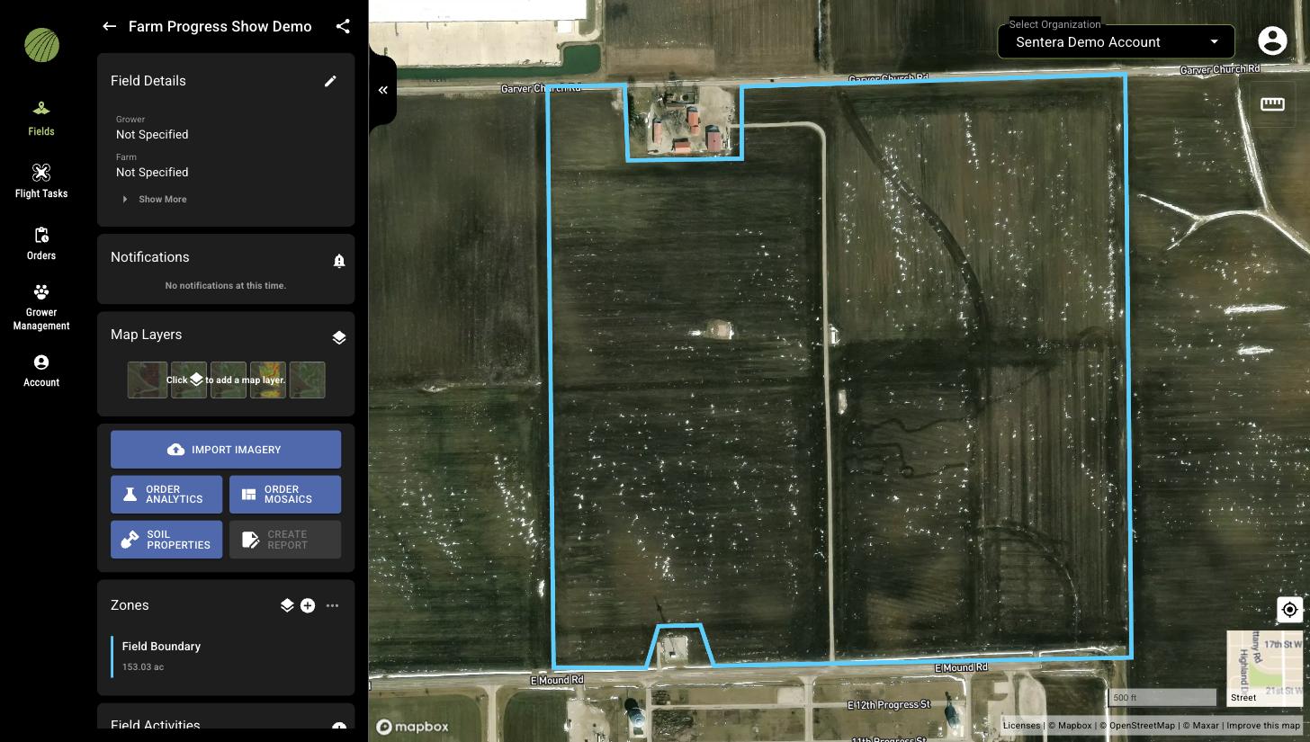
Selecting a field replaces the field list with the field view: cards for **Field Details**, **Notifications**, **Map Layers**, the action buttons, **Zones**, and **Field Activities**, with the field boundary drawn on the map.

<figure><img src="https://4042936416-files.gitbook.io/~/files/v0/b/gitbook-x-prod.appspot.com/o/spaces%2FNnNa4XKy1hMfEEmHLPqZ%2Fuploads%2Fgit-blob-d8b934a9b3dbf6bf84b6cc05f8735b57848b97ad%2Ffa-web-field-view-overview.jpg?alt=media" alt="The field view for a field with the Field Details, Notifications, Map Layers, and Zones cards and the six action buttons"><figcaption><p>The field view before any map layer is added.</p></figcaption></figure>

| Card or button       | What it does                                                                                          |
| -------------------- | ----------------------------------------------------------------------------------------------------- |
| **Field Details**    | Grower and farm. **Show More** reveals area, state, and city. The pencil opens the field for editing. |
| **Notifications**    | Messages about this field, such as a completed order.                                                 |
| **Map Layers**       | The layers currently shown on the map. The layers icon opens **Add Map Layers**.                      |
| **IMPORT IMAGERY**   | Upload photos, a QuickTile, or a mosaic to this field.                                                |
| **ORDER ANALYTICS**  | Order a stand count, tassel count, or another analytic from a survey.                                 |
| **ORDER MOSAICS**    | Order RGB, crop health, multispectral, or elevation mosaics from a survey.                            |
| **SOIL PROPERTIES**  | Soil data for the field.                                                                              |
| **CREATE REPORT**    | Build a PDF report. The button is available once at least one map layer is shown.                     |
| **Zones**            | The field boundary and any zones you have drawn.                                                      |
| **Field Activities** | Crop seasons and the activities recorded in them.                                                     |

The arrow at the top of the panel returns to the field list. The share icon next to the field name shares this field.

## Related pages

* [Find a field](/fieldagent-documentation-updates/fields/find-a-field.md)
* [Map layers](/fieldagent-documentation-updates/view-and-analyze/map-layers.md)