---
description: Learn how enable Terrain Informed Flight (TIF) on your Flight Plan.
---
# Terrain Informed Flight
{% hint style="success" %}
The app uses Google's [Elevation API](https://developers.google.com/maps/documentation/elevation/overview) to determine altitude offsets based on your drone's takeoff location.
{% endhint %}
***
## Motivations
* I want to maintain a consistent [Ground Sample Distance](https://support.pix4d.com/hc/en-us/articles/202559809-Ground-sampling-distance-GSD-in-photogrammetry) (GSD) during my flight.
* My [flight specification](../../faqs#data-collection-best-practices) requires TIF.
***
## Requirements
* You must have a [data connection](../../requirements/apple-devices#general) to build a TIF flight plan.
* [Flight Plan Export](flight-plan-export) requires you to set your takeoff location **before** exporting.
***
## Steps
From the [Flight Planning](fly-a-field-boundary) screen:
1. Tap on Terrain Informed under Options.
You can now tap on Review to see the altitude and elevation values.
**Additional steps are below**, depending on how you plan to execute your flight plan.
***
## Fly a Drone
You will be prompted to review the terrain and elevation values during the preflight check:
1. Tap on Accept on the top right.
Verify Flight Plan
{% hint style="success" %}
By tapping Accept, you take full responsibility for the drone's behavior during flight.
The app provides TIF as a convenience.
{% endhint %}
***
## Flight Plan Export
[Flight Plan Export](flight-plan-export) supports TIF.
### Requirements
* You must have your drone deployed at the desired takeoff location.
* You must have a [data connection](../../requirements/apple-devices#general).
* You must have [Location Services](https://support.apple.com/en-us/102647) enabled for the app.
### Steps
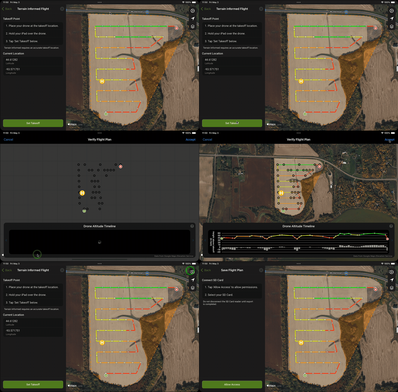
During export, you will be prompted to:
1. Deploy your drone at the desired takeoff location.
2. Hold your Apple device over the drone.
3. Tap Set Takeoff
4. Tap Accept
The export will then proceed normally.
{% hint style="warning" %}
**Do not** **move** **your drone** after specifying the takeoff location.
{% endhint %}
Set Takeoff for Flight Plan Export
{% hint style="success" %}
By tapping Accept, you take full responsibility for the drone's behavior during flight.
The app provides TIF as a convenience.
{% endhint %}